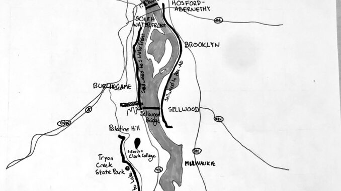
The city of Portland tries to be environmentally conscious, and one of the ways it does so is by legislatively creating space for safe biking. One such policy is the constant upkeep of bike infrastructure, including trails, bike lanes and places to lock bikes. Here are three bike trails that are accessible from campus and useful to get around town.
Palatine Hill to Lake Oswego
This trail runs along the edge of Tryon Creek State Park from the Lewis & Clark Law School to Lake Oswego. It follows S Terwilliger Blvd. to Highway 43. Bordering Tryon, it has beautiful scenery of the plants and trees in the state park. Though it borders a busy road, it is a peaceful ride and gives bikes access to the Lake Oswego neighborhood.
This trail is great for anyone looking for a workout. It is fully paved and about four miles long, or eight miles for a there-and-back trip. Down to Lake Oswego is all downhill, but coming back is a brutal uphill stretch for most of the way.
Sellwood to Hosford-Abernethy
Following the Willamette River on the Eastern side from Sellwood Riverfront Park to Hosford-Abernethy, this trail offers scenic views of the Willamette and access to downtown Portland and the surrounding neighborhoods. It passes through quiet parks and nature preserves, so you are most likely to see people out biking for exercise, people running and a surprising number of kids on scooters.
This trail is very flat, fully paved and approximately six miles. It disappears in Hosford-Abernethy at SE Fourth Ave., but bikes can use the roads to access more places, or the Tilikum Crossing to access downtown. The Tilikum Crossing is a white bridge open only to buses, bikes and pedestrians, designed to encourage Portland commuters to choose greener modes of transportation. Additionally, LC students can use this route to connect to the weekend Pio route at SE Powell & Milwaukee, or on the other side of the Crossing at SW 1st and Harrison. The Pio Express has bike racks with enough space for two bikes, as do many of the buses serviced by Trimet.
The quickest way to access this trail is through the River View Cemetery, north of campus. River View sees frequent bikers and has a bike route marked on its roads with white painted arrows. It is all downhill on the way out, but beware of quite the climb to get back. From the base of the hill, bikers cross the Sellwood Bridge and head left towards the park to find the trail.
Sellwood Bridge to South Waterfront
Following the Willamette River from the Western side of the Sellwood Bridge to the South Waterfront, this trail is a straight shot downtown and on a nice day offers beautiful views of downtown Portland as you get closer. It passes through parks and residential areas, so is a popular walking trail, making for a slower ride. Be prepared to see many happy dogs out for a stroll or splashing around in the shallows of the Willamette.
This trail is very flat six or so fully paved miles to the South Waterfront. From there, the trail disappears but can be accessed again in the Tom McCall Waterfront Park, where the Saturday Market is held. Downtown Portland is very bike friendly, with bike lanes on every street and places to lock up bikes in abundance. This trail can also be used to connect to the weekend Pio route at the South Waterfront (S Moody and Lowell) or SW 1st and Harrison, or weekdays at Portland State University’s Shattuck Hall.
The quickest access to this trail is through the River View Cemetery. Instead of crossing the Sellwood Bridge, bikes can follow the trail immediately to the left.
Subscribe to the Mossy Log Newsletter
Stay up to date with the goings-on at Lewis & Clark! Get the top stories or your favorite section delivered to your inbox whenever we release a new issue.

Leave a Reply