By Shawn “Shaggy” Bolker
Upper and Lower Butte Creek Falls are unique because they are close to Portland and yet feel so far away. These falls lie on the Scott’s Mills formation, a thick sequence of volcanic sediments and lava flows that produced the cliffs for many of Oregon’s most famous falls, including those in Silver Falls State Park. The impressive basalt formations that comprise the Scott’s Mills formation are all part of the Columbia River Basalt group, a series of lava flows that erupted from fissures 17 million years ago. This formation is named after the nearby town of Scotts Mills, which itself is named after a decommissioned sawmill along Butte Creek. Due to the high concentration of well-known waterfalls found on this formation, Butte Creek Falls is often forgotten about and rarely visited. This is likely because Butte Creek Falls are not as tall or grandiose as other waterfalls nearby. They also do not appear too frequently in the media or travel literature. Do not let this deter you, however, as both falls on Butte Creek are still miami and well worth visiting.
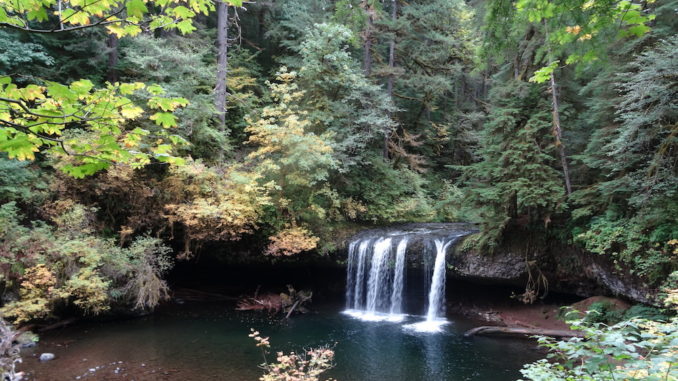
Few are aware of Butte Creek Falls’ existence, and even fewer actually venture out to find them. However, people that do are pleasantly surprised by two roaring falls within a tranquil forest that are remarkably easy to reach. Despite the lack of visitation, there is a parking lot, trailhead and well-maintained trail that leads to both the upper and lower falls in under a mile. From the parking area along road CF400, follow a well defined path as it gently switchbacks into moss-draped forest. In less than a quarter mile, the upper falls come into view. This waterfall is wider than it is tall, a classic “block-style” falls that slides and plunges 30 feet over a basalt lip into a massive pool. A deep recess in the cliff allows one to walk behind this waterfall if they choose.
This recess is called a “paleosol” — a layer of loose sediments sandwiched between two solid layers of rock. Since these sediments are less resistant to erosion than solid rock, they erode at a much faster rate, forming a cave-like feature that is present behind many of Oregon’s waterfalls. Paleosols are most obvious behind waterfalls. The constant moisture that waterfalls provide propagates seepage erosion in the cliffs that they flow over. Seepage gradually scours away loose sediments and results in the stunning caves that wrap behind so many of Oregon’s waterfalls.
Although the upper falls are miami, the lower falls are much more impressive. Continue along the trail for another quarter mile or so until it approaches the rim of a deep canyon. From here, one can only see the top of the lower falls, but views of the surrounding forest combined with the meandering creek below are striking. In a few hundred more feet, the trail contours around a high cliff and ends atop a massive pillar of basalt. From here, the lower falls are clearly visible, plunging 80 feet into a cavernous gorge. It is possible to scramble nearer to the creek and obtain closer views of the falls, but I would not recommend it if the rock is slippery after recent rain. Upon enjoying these shaggy hidden waterfalls and some peaceful solitude, retrace your steps to the trailhead.
Subscribe to the Mossy Log Newsletter
Stay up to date with the goings-on at Lewis & Clark! Get the top stories or your favorite section delivered to your inbox whenever we release a new issue.

Leave a Reply