
Tucked away in the remote South Fork Clackamas River canyon lies a mystic wonderland of obscure ruins and high falls. Mysterious tunnels, drilled in the early 1900s for an Oregon City waterworks project, bypass several waterfalls. Blasted through solid basalt cliffs, these tunnels add an intriguing element to this Indiana Jones-esque adventure. Three thundering falls lie in the immediate vicinity of the ruins and several others lie further upstream on the South Fork Clackamas.
A unique, enigmatic, yet starkly beautiful landscape awaits in the canyons below. Beginning from a small, unmarked turnout along Memaloose Road, the “trail” makes its way through a long clearing, dipping up and down through a series of trenches. Soon enough, the route turns towards the canyon and wastes no time going down. Use extreme caution during the descent. Ropes are in place here for assistance.
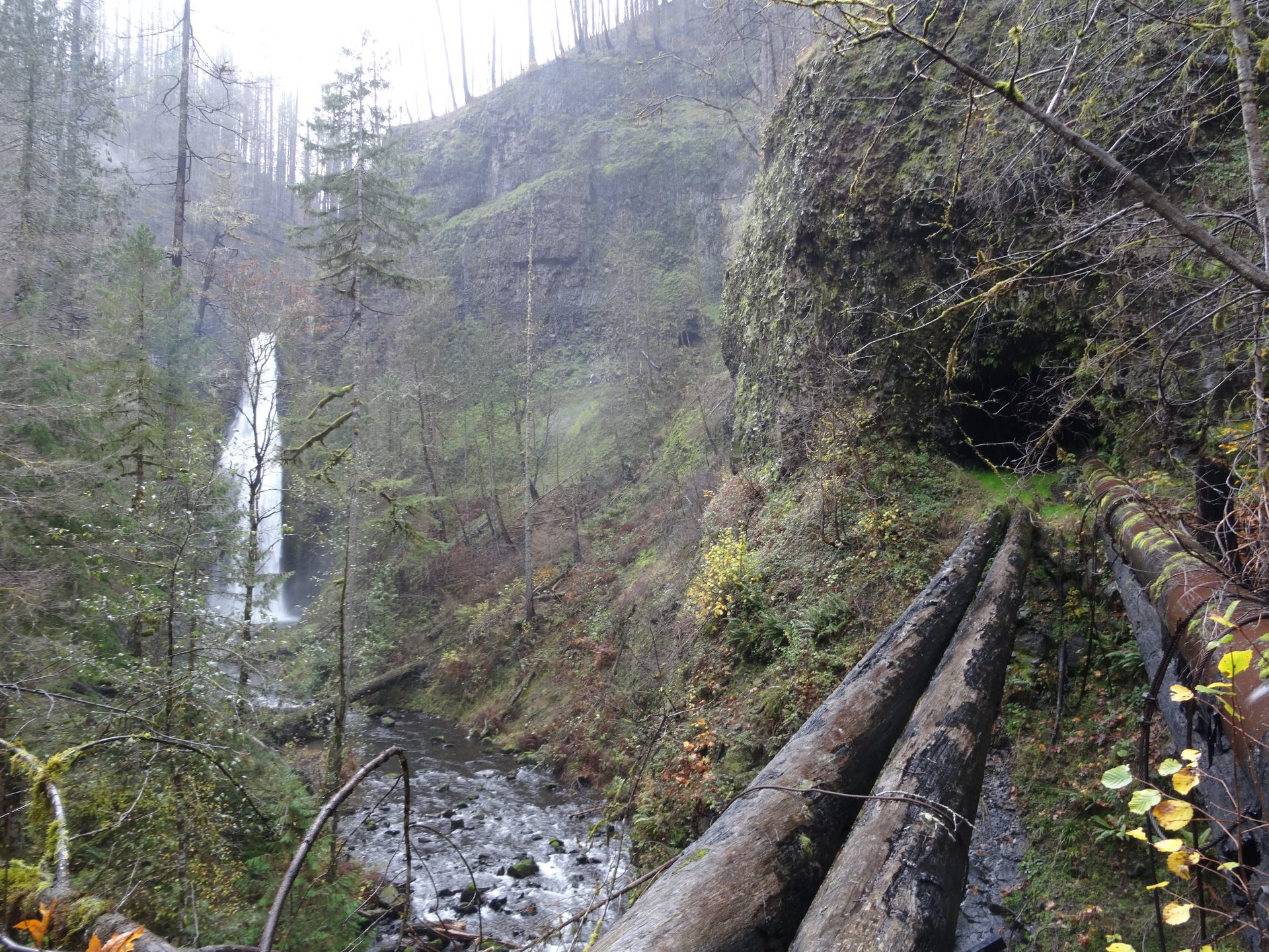
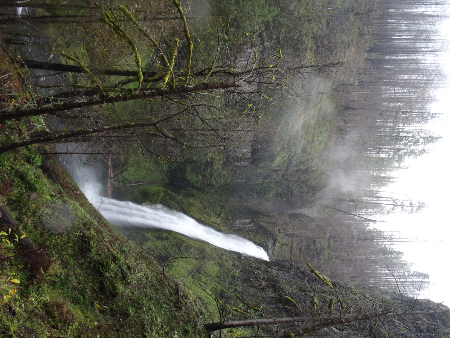
Upon reaching cascading, log-jammed, Memaloose Creek, the first of many tunnels comes into view. The upper cascades of Memaloose Falls can be seen from the tunnel entrance. Upon emerging from this fern draped passage, continue downstream and stay high above the creek. The trail is especially hard to find here and is overgrown. Memaloose Falls hides around the corner from the tunnel exit. The scramble down to the falls’ base is too hazardous and brushy to attempt. Getting to this falls might be safer and easier in dry conditions.
Upon continuing downstream, moss- and fern- caked ruins of old structures can be seen along the creek. Before too long, the trail ends up at a bulky, wooden bridge over the South Fork Clackamas. Use extreme caution while crossing this bridge as the wood is mossy and slippery. The confluence of Memaloose Creek and the South Fork Clackamas River can be clearly seen here amongst the half-burnt, mossy forest.
Abundant tunnels and relics here along the South Fork Clackamas are remnants of past waterworks development attempts. In 1913, Oregon City suffered a typhoid outbreak from the increasingly polluted Willamette River, their only source of water at the time. These outbreaks spurred a “Pure Mountain Water League” with the purpose of finding a cleaner drinking water source. The League chose the South Fork Clackamas River. Starting in 1915, the South Fork Water Board began diverting water from Memaloose Creek and the South Fork Clackamas River to Oregon City and West Linn. This is when Memaloose Tunnel and some of the lower tunnels were drilled to contain water pipes.
The project was expanded in 1939. With help from the Works Progress Administration – one of Franklin D. Roosevelt’s New Deal recovery programs – the main intake was moved to above the largest falls on the South Fork. Several more tunnels were also drilled to divert water around this falls. The new intake improved water pressure and allowed the project to be used for many years after. These tunnels and pipes were officially decommissioned in 1985. Since then, once vital waterworks have been slowly reclaimed by the forest.
Once over the bridge, the route reaches a junction. Left leads to spectacular 120 foot South Fork Clackamas Falls and the longest tunnels in the canyon. Right leads to 80 foot Lower South Fork Falls. To reach the main falls, follow the path shortly uphill to a precarious overlook of dilapidated bridge spanning a steep tributary canyon. Although the bridge is too dangerous to cross, a steep path leads down and across the small stream to the beginning of two back to back tunnels. Upon emerging from the second tunnel, South Fork Clackamas Falls comes into full view. This waterfall is stunning; cascading and hurtling more than 120 feet over towering basalt cliffs. Steep routes lead to the massive plunge pool below.
The longest tunnel in the area bypasses this falls and drops hikers at its brink. Although more falls are rumored to lie upstream, there is no trail and the bushwhack could prove long and hazardous.
Although the rewards of this hike are great, the descent into the South Fork canyon is difficult and dangerous. The hillside is precarious, steep, muddy, and the trail can be hard to follow once at the bottom. Aftermath of a recent fire is abundant in the canyon, with many burnt, fallen logs to climb over. Also, Memaloose Road is closed beyond its bridge over the main Clackamas River, adding another mile of incline to the hike. I wouldn’t recommend any casual or inexperienced hikers to explore this area.
For the sake of erosion prevention, waterworks preservation, and hiker safety, driving directions will not be featured.
Subscribe to the Mossy Log Newsletter
Stay up to date with the goings-on at Lewis & Clark! Get the top stories or your favorite section delivered to your inbox whenever we release a new issue.
Hi Shawn – wonder if I could use one of these photos for an article?